The export data option found in the toolbar is used to accessed the Export tool.
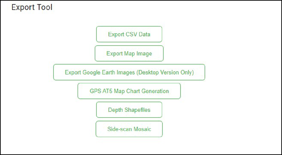
Export CSV data
Use the Export CSV Data option in the Export data dialog to export coordinate points or kriging grid data processed for depth, vegetation, and composition for further analysis in a third-party statistical or GIS software.
Exported data is provided as point-feature data files saved in a standard delimited format and in the WGS84 global coordinate standard. This allows you to have full control to project and convert your data into any desirable geospatial format.
Point data exports the processed coordinate data available in the EcoSound summary report and includes all created data along a GPS track. Inspecting the point data in GIS will give you an advanced knowledge of data spacing, data cleansing, and data clustering.
Grid data represents the kriging grid cell node values that were produced from the point data. These data can either be converted to a raster dataset in GIS for advanced spatial analyses or map creation or be analyzed as is in GIS or a spreadsheet (e.g., each line in the grid spreadsheet represents a grid cell of a known size – default is approximately 5 m).
EcoSound data are gridded in WGS84 coordinates, so grid cell sizes are not precise integers. For example, grid cells that are reported as 5-m in automated report metadata may actually be 5.2 m x 5.1 m grid cells. This might be important for generating precise custom water volume estimates from exported grid data.
Export map image
Use the Export Map Image option in the Export data dialog to export high resolution imagery (*.png or *.jpg formats) from BioBase.
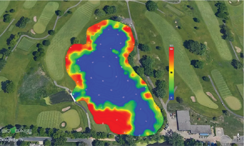
Export Google earth images
Use the Export Google earth images option in the Export tool dialog to export exact replicates of your BioBase EcoSound maps as Google Earth satellite imagery.
The Google Earth feature converts the *.png images to Google Earth file formats:
- *.kml - smaller and reference the images on BioBase servers.
- *.kmz - larger and are exact copies of the images stored in the BioBase servers. This format is best for users who wish to archive local copies of their BioBase maps.
The image shown below is an example of an exported Google Earth image from BioBase.
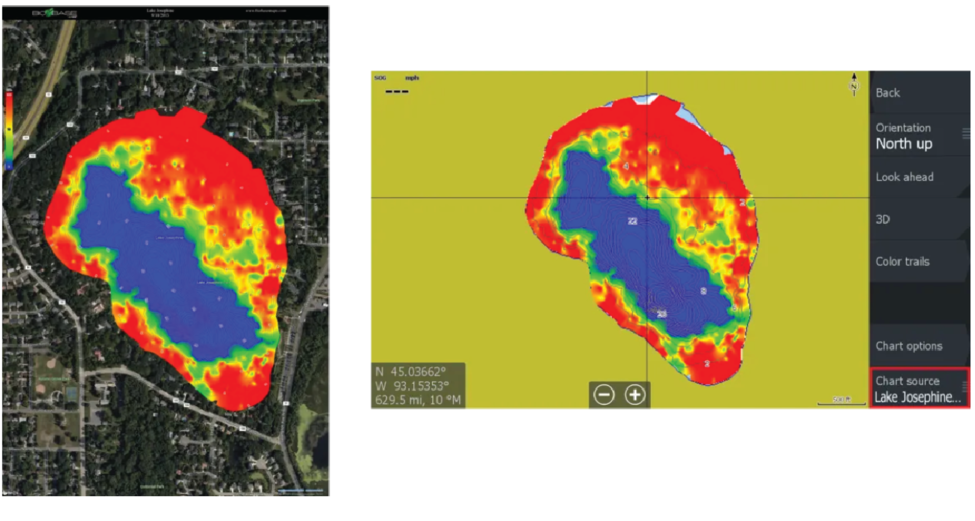
GPS Chart generation
You can export the bathymetry, aquatic vegetation heat map, or bottom hardness map into a file format (*.AT5) that is compatible with most of Lowrance and Simrad MFDs. This enables you to return to surveyed areas of interest and precisely target follow-up surveys or management actions (e.g., strategic taking of water or aquatic plant samples, placement of fish habitat structures or aeration equipment, precision applications of aquatic herbicides, etc.).
Use the GPS Chart generation option to export BioBase EcoSound maps as Lowrance or Simard Charts.
The images below is an example of the vegetation biovolume heat map that is displayed in the BioBase trip viewer (left) and the exported vegetation biovolume heat map that is displayed in a Lowrance MFD.
Depth shapefiles
Use the Depth Shapefiles option in the Export tool dialog to download the shapefiles of depth contours associated to your trip.
The downloaded shapefiles can be used as a supplementary survey data when a detailed water volume analysis for aquatic habitat and fisheries management is required.